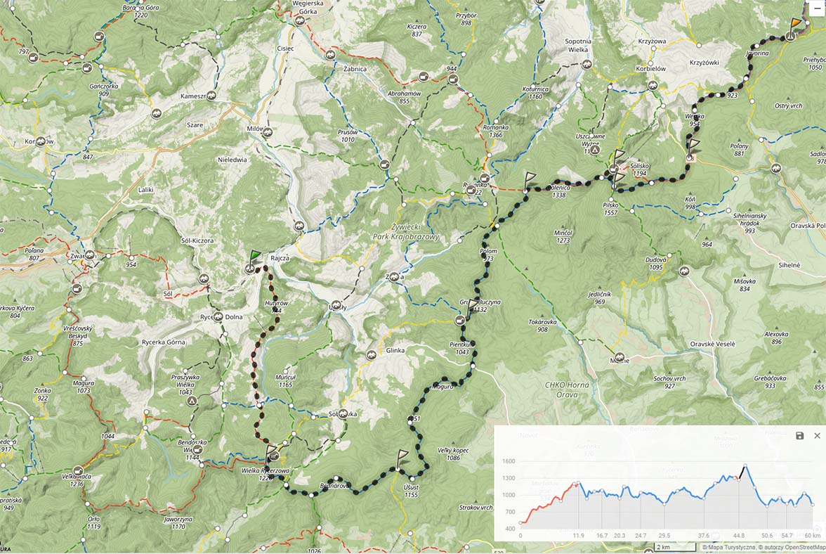
 XI Wyrypa Beskidzka - route 60 km
Needed water: min. 2 liters
Possibility of shopping: 3 hostels on the route
Length: 60 km
Elevations: +3100/-2850 m
The highest point: Pilsko, 1557 m npm
Lowest point: The knight, 508 m npm
First 11 kilometers are described in the entry From Rycerki up Soła, let me quote and add a bit.
The knight (Lower and Upper) was founded during the Wallachian colonization in the 17th century, was mentioned on the maps of the Duchy of Oświęcim z 1676 year. Throughout its history, it has changed hands, most often located in the key of Żywiec goods. We start our hike along the red trail from the train stop itself. Right after crossing the bridge, on the right side it is worth paying attention to the cross standing at the crossroads, placed according to sources v 1900 year. About a kilometer we move along the asphalt road to turn right after the bridge on the Rycerski stream and go between the houses, and then the approach immediately begins, which you have to get used to on this tour. About one-third of the distance between Rycerka and Mlada Hora, you will pass the ski lift on your right. The valley on your left to the Danielka valley, and right behind it there is a huge Muńcół massif. If you glance back and find a tall church spire, know, that it is Rajcza and her church of St.. Wawrzyniec and Kazimierz. Then, a little interesting fragment, basically all the time uphill, all the way to a very large hall - this is Młada Hora. Follow you around 1/7 routes! Chyz shelter at Bacy's (the last time I was there was) closed.
You have to be a little careful on the mountain pass, so as not to accidentally fall on the blue trail, we are moving red all the time! Behind the estate and the pass, we return to the sad approach. About 3 km are left to the hostel at Rycerzowa. You still have a lot of time, to get there - the hostel buffet is waiting for Wyrypa participants until 2.0o at night. You will pass several small clearings on the way, but the beginning of another large hall to Hala Rycerzowa.
Shelter (bachelor PTTK) exists since 1975 year. On a sunny day you can see a beautiful panorama of the border range. Bathroom (with potable water) it is located at the bottom left of the entrance, in the basement.
The next step is quick, short and pleasant approach to Rycerzowa (1226), hence again a beautiful panorama to the north - the settlements in the Soła Valley are beautifully visible. At the top, there is a fork in the trail - here we change the trail to blue. We will follow this route until the finish of this route (with a small reflection). From Rycerzowa we go down to the Przysop Pass (840). The name Przysłop comes from the Wallachian "Prislop", what was meant to mean "high mountain pass". One of the most characteristic ascents of Beskid Żywiecki - Świtkowa begins on Przysłop. It is very short, but very steep at the same time, because on some episode 300 we gain meters 250 meters high. Fortunately, the next few low rollovers are called Równe Beskid for a reason.
After about an hour and a half from Przysłop, you will reach a place called Lord's Stone. Here you can find the Orava State border stone excavated here in the year 1888. About two kilometers further you will come to the faint Podoszust Pass (946), you will recognize them after the approach to the Cheater begins and the yellow one turns right, Slovak train to Oravská Lesná. On the northern slopes of Oszust there is the Oszust forest reserve, which protects the lower montane forest, which is a remnant of the Carpathian Forest. Access to the border post no 140 will mean, that you are on top of the trickster (1155). From here, you will be around 3 kilometers long, gentle descent, and then a really gentle approach to Jaworzyna (1050). Another delicate one from Jaworzyna, extended descent to the Glinka Pass (845). Do 2001 year there was no asphalt road here yet. This one was built to start a border crossing here, which operated until Poland and Slovakia joined the Schengen Agreement. From the mountain pass, there is an approach to the next Jaworzyna (1045), and from here to Krawców Wierch (1080). In Hala Krawcula there is a mountain hut for qualified tourism, even the untrained eye will notice the resemblance to the one in Hala Rycerzowa. They were created according to the design of the same man - Stanisław Karpiel. They were to serve qualified tourism, they are not designed to handle large groups, which results from their assumptions. Participants of the 11th Wyrypa Beskidzka can easily eat breakfast here from 7.00 morning.
The further hike follows the blue trail. The Połogi trail leads through a thinned out forest, without any major climbs, up to the Bory Orawskie Pass (930). When the visibility is good, you can see the Tatra Mountains or Mala Fatra from the ridge. At the pass, it is worth paying attention to the nearby rustling waterfall on the Bystra stream. The name Bory Orawskie refers to the highlander name of the peat bogs, which are located here - pines. From here begins another extended ascent to the top of Trzy Kopce (1216).
We stick to the border ridge and the blue Slovak trail (which here coincides with the Polish red trail - the Main Beskid Trail). Hence one larger approach to Palenica (1343). From Palenica, descent to Hala Cudzichowa, from where there is a beautiful view to the north as far as Beskid Mały and to the north-east to Jałowiec. The proverbial walk to the shelter in Hala Miziowa is a stone's throw away, you just have to cross the indistinct peak of Sypurzenie.
The shelter at Hala Miziowa was built in the interwar period, during the war it served as a military point, where German soldiers were stationed. After the Second World War, it was put into operation very quickly and returned to operation, despite the fact that at the end of the war the equipment was stolen. Beautiful building, considered the most beautiful in the Polish Beskids, will burn in March 1953 year. For almost 40 for years, accommodation was provided here in farm buildings, who miraculously survived the fire. W 2004 year, reconstruction began, which was completed in 2014 year. It is one of the most magnificent hostels in the Beskids, which at the same time retained its shelter character.
We start our ascent to Pilsko from the shelter. Initially chaotic up the hill, however, it is worth sticking to the trail of the ski lift on the eastern side of the Miziowa hall - the yellow trail crosses it. The traverse is at times highly exposed and almost reflects the character of the high mountains. After approx 20-30 minutes, among the mountain pine we will see a symbolic grave, in a place where 1 September 1939 Franciszek Basik was killed in the year, alleged first victim of the war in Beskidy. After reaching the Five Mounds Mountain, it is worth adding a few hundred meters and reaching the very top of Pilsko, which offers a beautiful panorama of the Tatra Mountains, Babia Góra massif, Orawa Lake ... Unfortunately, the finish line is not visible - it is hidden behind one of the peaks.
We return to the Five Mounds Mountain, Taking a steep descent, following the blue signs, we quickly descend to the Glinne Pass. Slightly below the pass on the Slovak side, there is a shop, where you can stock up on typical food and other products. From the Glinne Pass, the last track leads to the finish line. Initial ascent to the top of Zimna (called Student - from the Slovak name Studená: that is cold, 935). On the Slovak side, a trained eye will see the remains of trenches from World War II. About a kilometer from Zimna, in the vicinity of the border post no 102, you can find a spring. A moment later, the yellow trail will turn right - this is a sign, that we reached the pass near Beskid Krzyżowski (Slovak: Half-mountain saddle), hence the gentle approach to Beskid Krzyżowski, and then a sharp descent to the Półgórska Pass. It is so interesting, that the road was supposed to pass this way, which was finally built over the Glinne Pass, a railway line from Żywiec to Námestov was to be built along with the road. Ultimately, Námestovo did not receive a railway connection, and the road was led in another valley.
From the Półgórska Pass, the last ascent - to Jaworzyna (1046). It stretches for almost two kilometers, however, these are the last two kilometers uphill, only less than the finish line 2 km of descent.