XI Wyrypa Beskidzka - route 110 km
Needed water: min. 2 liters
Possibility of shopping: 1-2 hostels on the route
Length: 48 km
Elevations: +2650/-2650 m
The highest point: The devils, 1725 m npm
Lowest point: Zawoja Wełcz, 627 m npm
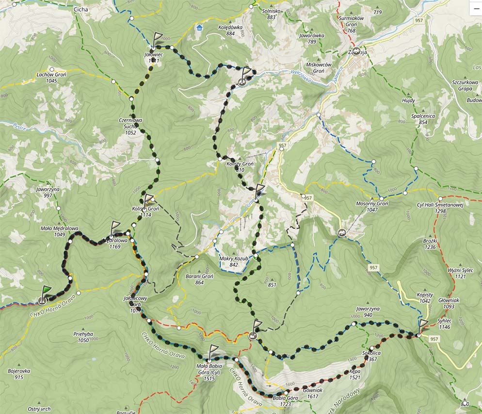
From the Student Tent Base on the Głuchaczki Pass, we set off to the east, constantly following the Main Beskid Trail. We go through very gently at first, quite extended approach towards Western Mędralowa, which we will reach after approx 45 minutes. The next peak is the main peak of Mędralowa, also called Modralová by Slovaks. It is the northernmost point of Slovakia, so on the top we can find a sign with the words "Slovenský severný pole". In the sub-peak clearing there is a shepherd's hut and a not very efficient spring. Behind the summit, the trail turns south sharply and we begin a gentle descent towards the Jałowieckie Pass - northern and southern..
The northern Jałowiecka Pass is also known as the Tabakowy Saddle. "Tabak" is a highlander term for tobacco. This pass, hidden in the wild Carpathian forest, was a place, in which smuggling of tobacco across the border took place, then still Polish-Hungarian. We can see this place on the Slovak yellow trail, which at this point turns towards Vyšný Tajch. The South Jałowiecka Pass, located further south, is easy to miss, however, it is worth mentioning, that the trade route in this place has a very long history and it has connected Zawoja with Orawa for centuries. Continuing the march towards Żywiec Rozstaje we will be forced to change the color of the trail to blue. This trail is named after Mieczysław Mączyński, president of PTT in Żywiec, tourist activist, which contributed to the development of tourism and the expansion of the shelter in Markowe Szczawiny. We start the over two-kilometer ascent to Mała Babia Góra (1517), also called Cyl. In this passage, we go over 400 meters vertically. The approach is demanding, however, remember, that you are climbing the third highest peak in the Polish Beskids - on this route you have reached the second highest peak of the Polish Beskids (Pilsko), and in a few moments you will be on the highest peak of the Beskids. Now, however, you can look around - Babia Góra dominates the view (in front of us, looking from the direction, from which we came), in good visibility, the panorama of the Tatra Mountains will open, in the south-west direction, a trained eye will spot Pilsko, Romance and even Skrzyczne (especially at night).
Descent to the Brona Pass (1408) it's pure pleasure, after which we will start another two-kilometer ascent to the "Queen of Bad Weather", Babia Góra (1725). The approach itself is rather monotonous, however, the views will reward them, which will open above the mountain pine border. It is also worth paying attention to the classic ones, alpine formation of floors of vegetation, which in Poland naturally occurs only in the Tatra Mountains and here. Above the mountain pine border, a range of natural pastures begins. The end of the ascent to Diablak - the highest peak of Babia Góra - requires attention, because it is almost the floor of the crag and we will be treading on bare rocks. The hardships of the approach, however, will be rewarded by a spectacular panorama - the Tatra Mountains dominate in the south, in the west it is clearly visible, where we came from, but let's not forget the view to the north, where the next ranges of the Beskids overlap, more to the west you can clearly see the Little Beskids, and to the east - the Middle Beskids with its multitude of stripes and hills.
Now, one of the most tiring descents on the entire route awaits us - the section 4,5 we will lose over a kilometer 700 meters high, to find yourself on the Lipnicka Pass (1014), colloquially called Krowiarki. The highest dirt road in the Polish Beskids runs through this pass, the southern part of which was built in 30 XX century, and the construction from the side of Zawoja was started only in 60. Karol Wojtyła participated in the construction of the southern parts, one more plaque is also devoted to him, because it is from here in 1978 year, he embarked on his last mountain trek before that, when he was elected to the See of Peter.
We are leaving the Main Beskid Trail, we set off on a pleasant journey along the blue trail, the so-called Górny Piła. Your drug, similar to Dolny Płaj, was built by the owners of these properties - the Habsburgs. Its importance and quality should be proved by the fact, that at the end of the 19th century, ladies in long dresses used to go this way, it was also used for hunting purposes. After approx 20 minutes we come to the Wet Stawek. It is the largest pond of landslide origin in Babia Góra, it's hard to miss (I guess, that there is a drought), located below the path on the right. After another 10 minutes walk to Szkolnikowe Rozstaje. Here green starts strongly uphill, very short, trail known as the Naturalists' Pearl. The name of the crossroads comes from Wawrzyniec Szkolnik, marker and guide.
However, we remain on the blue trail, moving further along the border of the lower and upper mountain ranges a little over 3 km we will reach the Lifeguards Turn. This is where the most difficult of the Beskid trails begins - Perć Akademików. We continue our journey to the. Hugo Zapałowicz in Markowe Szczawiny. The shelter in this place was built in a year 1906, it was rebuilt many times, after 101 years it was dismantled, and a modern one was built in its place, a modern facility stylistically referring to alpine shelters.
We leave the shelter along the green trail, continuing the descent to the south as far as Zawoja Wilczna itself, where we change the trail again - this time to black. We overcome a delicate approach to the Mylne Młaki estate, from where we go down to Zawoja Wełcza. Here we start the last larger ascent on the route - along the blue trail to Jałowiec. On 4 we gain almost kilometers of the route 500 meters high walking up a beautiful forest. The connection with the yellow trail signals the end of a tiring climb, However, all this will be rewarded by the view from Jałowiec (1111) towards Babia Góra.
Then we go down to the Trzebuńska Pass, to return to the trail of. Mieczysław Mączyński. From here, through Beskidek we go to the Klekociny Pass (864). In the original plans, the so-called Carpathian Highway was to be led here (We visited the other pass of the road earlier - these were the so-called Krowiarki), the construction of which began in 30. XX century. In recent years, the idea of this implementation has been revived, the result is a road through this pass.
From the mountain pass, take a steep path up the hill, about one and a half kilometer up the hill to Hala Kamiński. The once very large hall is now slowly overgrowing - this process is called secondary succession. At the end of the war, the German troops occupying the area dug shelters, which, however, were never used.
From here we continue, already softer, approach and we return to the top of the previously described Mędralowa, on which we return to the Main Beskidzki Trail - this time towards the west. From Mędralowa there is only a gentle descent to the Głuchaczki Pass, where is the finish line of the route 110 km.