 Swift Durbashka
Needed water: ok. 2 liters
Food on the road: after approx. 12 km
Length: ok. 20 km
Elevations: +720/-870 m
The highest point: Smerekov, 1000 m n. p. m.
Lowest point: the estuary of Grajcarek to the Dunajec, ok. 440 m n. p m.
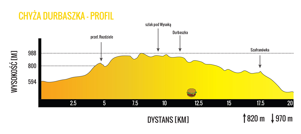
Chyża Durbaszka takes its name from the peak of Durbaszka, under which the shelter is located (if you were going to(a) get there not during the competition, I loyally warn you: they don't serve alcohol there, formally it is a house of culture), and during the competition - a food point. The first Chyża Durbaszka took place in 2015 and it was won by Vadim Kujalanskas with time 1:50:03, w 2016 This result was improved by Kacper Piech about the law 20 minutes and present (March 2017) track record is 1:31:29.
The route begins in the ski resort in Jaworki, one of the villages of the so-called Ruthenia Szlachtowska. This name refers to four villages (noble, Jaworki, White Water, Black Water), which until voluntary resettlement in 1945 year and then until the resettlement of the year 1947 (this is for Wisła action) were inhabited by the Lemko people. Guesses about the time of the uprising lead to the turn of the 15th and 16th centuries - sources from the beginning of the 16th century already indicate the existence of Szlachtowa, and those from the second half of that century already mention the existence of Jaworki, it can therefore be assumed that the village already existed earlier. From 2009 year, the ski resort "Arena ski Jaworki" operates in Jaworki, where the competition has a starting line.
We start from a very gentle descent towards the "center" of Jaworek, but in a moment we turn towards the red and yellow trails, where we are slowly but steadily gaining altitude, run through Biała Woda. This village does not exist at present, she was displaced. It left behind such relics as wild orchards and foundations of houses, it is worth looking around. It's worth taking a look around as well, to notice the beautiful rock outcrops, mainly limestones, however, in the reserve (so, Biała Woda is a landscape reserve. By running there you will see why) you can also find basalt rocks there. Smolegowa Skała clearly dominates the bifurcation of the trails (look for her on the left side). We are going up gently all the time, however after 4 km the slope of the trail increases significantly, because the last part of the ascent to the Rozdziela Pass begins (803 m. n. p. m.) and then along the ridge towards the southwest. In a few moments, the ascent gives up (and turns into quick, short descents), then it is worth raising your head and looking around at the beautiful panorama reaching at times as far as the Tatra Mountains! Apart from the Tatra Mountains, you can also see Beskid Sądecki (mainly behind you), Czergowskie Mountains in Slovakia (on the left), and if the conditions are really good then ... Beskid Żywiecki waves you from the right side.
Uphill, which started at the Rozdziela Pass, it really ends only at the highest point of the entire route, that is, on the slopes of Smerekowa, after approx. 4 km i 300 meters of ascent. We basically run the next three kilometers on the spirit level, without major ascents and descents, we traverse (together with the blue trail) the highest peak of the Little Pieniny - Wysoka (1050 m. n. p. m.; if you are not in a rush, it is worth reaching the top, several dozen stairs lead there, and the view is worth every step. With good visibility you can see from there 3 countries - Ukraine joins Poland and Slovakia, and apparently sometimes even the Czech Republic, but I have not seen it with my own eyes). When running under Wysoka, it is also worth looking at your feet, because we are in the area of another nature reserve - Wysokie Skałki. It is another landscape reserve, numerous flowers and birds are protected here. Immediately after Wysoka we traverse the Borsuczyn peak and quickly descend to the shelter under Durbaszka. Shelter, though it is hard to believe, it once served as a shepherd's hut, then as a scout hostel, tourists are served there from the beginning 70. XX century. There is a food point during the competition and time is measured. It is the twelfth kilometer of the route.
We return to the ridge, we also come back to the beautiful views, The whole is of course dominated by the nearby Tatra Mountains on the left, a trained eye will notice Radziejowa on the right, clearly marked Jarmuta, which towers over Szczawnica (on the right front, looks a bit like a volcano) or Bereśnik on the other side of Grajcarek. We are all the time walking very close to the border along the blue trail. From Durbaszka, the main activity on the route will be lowering heights. We do it slowly and systematically, passing one small ascent along the way, which you probably won't even notice. After 5 km we reach Szafranówka and the route to the finish line already coincides with the Hardy Rolling route, Meaning: we run literally a bit from Szafranówka, after which a really thick descent begins until the first buildings, then a slight flattening and only a bit up Grajcarek.